
The search for missing Malaysia Airlines flight MH370 has earned Geoscience Australia a global award for its cutting-edge work in mapping the deep reaches of the Indian Ocean.
The Australian organization was selected from more than 100,000 organizations world-wide to receive the Esri Special Achievement in Graphical Information Systems (SAG) award for its innovative use of GIS technology to advance the mapping of deep oceans. It received the award in San Diego.
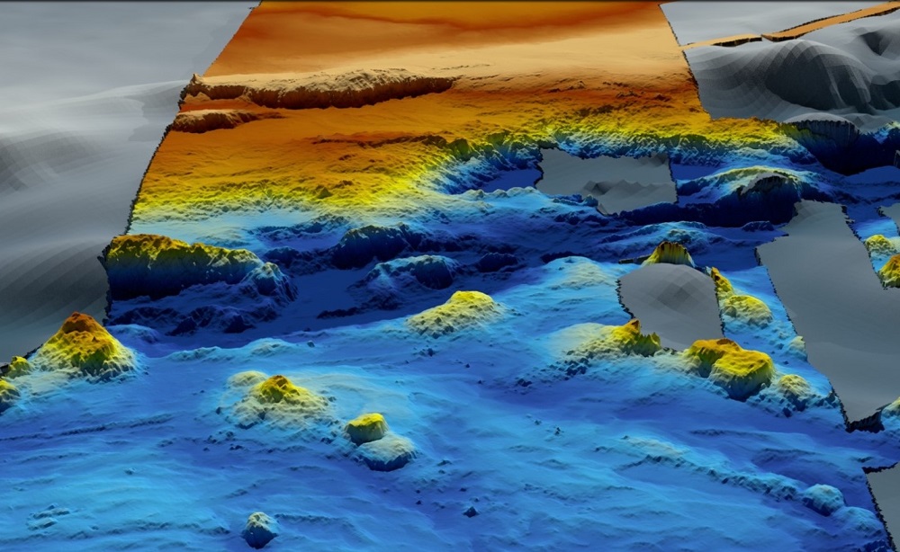
Geoscience used Esri's advanced mapping and analysis software to draw insights from what turned out to be the biggest marine survey ever conducted.
While the searchers failed to find the missing plane, the MH370 operations led to discoveries such as underwater volcanoes, mountains and trenches. It also improved the understanding of ocean depths for rescues of up to 2,000m.
The maps created by Geoscience provided a more precise insight into tides, seafloor depth, ocean temperatures and seabed terrain than had been available previously.
“Using GIS technology to create an accurate and detailed picture of the seafloor is critical for understanding factors such as: environmental change; tsunami forecasting; mineral extraction; oil and gas exploration; infrastructure construction; and cable and pipeline routing – to name just a few areas,’’ Esri Australia and Esri South Asia Group managing director Brett Bundock said in the award announcement.
“For example, petroleum companies can use the technology to more effectively plan and manage their ocean pipeline network, to ensure their real-time operations are optimized and the risk of oil spills is mitigated.
“Commercial fisheries can use these insights to pinpoint the locations of fish and dramatically decrease the time taken to catch their allowance – which in-turn generates cost-savings and environmental benefits from reducing fuel consumption and time spent on ocean.
“Telecommunications organizations, which are increasingly investing in submarine cables for inter-country connectivity, will have a clear picture of the most efficient and safe location for their seabed cable network.”
WATCH: Virgin Galactic fires up.
Geoscience Australia chief scientist Dr Adam Lewis said there had been a need to create a detailed and accurate picture of the ocean floor in order to determine what may have happened to the MH370 debris.
“To do this, we used GIS technology to map and analyze an unprecedented volume of data, including over 278,000 square kilometres of shipboard bathymetry data, and another 432,000 square kilometres of data collected on the journey to and from the search zone,’’ he said.
“The visual language of maps is a very effective way to communicate, so we used dynamic real-time maps to share updates about the search and our findings with other government agencies in Australia, Malaysia and China; members of the public; and – most importantly – the families of those on board the flight.
“The search also demonstrated the great value of open data. Some of the key data and insights we generated in the search has been made available to anyone in the world in high-resolution format."
Geoscience was also recognized for establishing a new multi-organizational cooperative group – AusSeabed – to coordinate seabed mapping activities in Australia.
READ: MH370 data to help build a global map of the ocean floor.
This initiative will contribute to the international mapping objectives of the Nippon Foundation- GEBCO’s Seabed2030 project to produce a high-resolution map of the world's ocean floors by 2030.
Have questions or want to share your thoughts?