MH370 video: Where the aircraft may lie

By Geoffrey Thomas Thu Dec 11, 2014
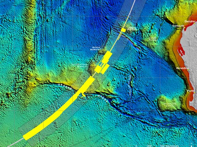
The Australian crash investigator has released the first video animation (below) of the ocean floor where MH370 is believed to lie.
The Australian Transport Safety Bureau search teams have now mapped 200,000sq kms of the ocean floor off Perth, Western Australia.
Before the new underwater search for MH370 could begin, it was necessary to accurately map the sea floor to ensure that the search is undertaken safely and effectively.
Bathymetry survey vessels have spent months, scanning the sea floor with multibeam sonar to gather detailed, high-resolution data.
The data has revealed many seabed features for the first time. This computer-animated ‘flythrough’ shows a visualisation of some of the sea floor terrain in the search area.
To this time however, only 9000sq km –or 5 per cent - of the ocean floor that has been mapped has been searched by ships towing side-scan sonar looking for wreckage.
In fact one ship, the Fugro Equator, continues to conduct bathymetric survey work in the search area.
Two ships – the GO Phoenix and Furgo Discovery - are now searching for MH370 with the side-scan sonar which can operate to depths of 6000m.
Last month the chief of the world’s largest international airline expressed grave concerns that MH370 will be given up as lost as part of an international cover-up.
Tim Clark, President of Emirates, told AirlineRatings.com yesterday that he has been inundated by grieving relatives, and theorists pressuring him to continue the pursuit of the truth.
Read:Airline Chief says MH370 a coverup
“Many mathematicians have done extensive calculations and have detailed them in their emails to me,” said Mr Clark. “None believe the current hypothesis.”
“We cannot allow MH370 to become a “National Geographic” mystery. “We must get to the truth.”
Also last month Australia’s crash investigator dismissed reports that there is disagreement among the expert teams that are calculating the search area for MH370.
The Australian Transport Safety Bureau chief commissioner, Martin Dolan, said that there were two priority search areas for MH370 because the five teams had been using differing methodologies to calculate the likely flight paths of the aircraft based on satellite communications data.
Have questions or want to share your thoughts?