MH370 search a rich source of undersea data

By Steve Creedy Tue Jul 18, 2017
Sea floor mapping conducted off Western Australia during the search for Malaysia Airlines flight MH370 is being hailed as an invaluable resource for the scientific community that has revealed previously unseen details of the Indian Ocean depths.
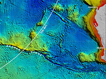
Although it failed to find the wreckage, the first high-resolution look at the remote area of the Indian Ocean shows never-before-seen-detail of ridges six kilometres wide and 15 kilometres long that rise 1500m above the sea floor.
There are also fault valleys 1200m deep and five kilometres wide.
It was one of the biggest marine sweeps ever conducted and searchers collected 278,000 sq. kms of bathymetry data from the wider search area 2000kms from Perth. This increased to 710,000 sq. kms when data acquired during transits taking up to six days transit between port and the search area are included.
The information has been used to make maps with a resolution 15 times higher than those made previously using satellites.
Data from the search’s first phase were released by Geoscience Australia Wednesday to the international community with more to come in mid-2018.
The first phase involved data collected in the Southern Indian Ocean off Western Australia during a bathymetric survey used to map the seabed and lay the foundations for a more detailed search.
The detailed search of a 120,000 sq, km area initially believed likely to contain the debris failed to find any sign of the plane, which disappeared in March, 2014, with 239 passengers and crew on board.
Subsequent drift studies made possible by the discovery of aircraft debris caused experts to revise their estimates of its likely position to an area to the north of the original search zone.
However, the Malaysian, Australian and Chinese governments decided to suspend the search. which had already cost about $A200m, before the newly identified area could be thoroughly probed.
Geoscience Australia was involved in the Australian Transport Safety Bureau-led search because of its expertise in marine mapping. It was also responsible for processing and analysing data from the two phases of the search.
The bathymetric data in the first phase was used to develop maps of the sea floor topography with a resolution 15 times greater than those made previously using satellites. These aimed to allow the second phase, a more detailed underwater search using towed and autonomous underwater vehicles, to safely negotiate obstacles.
The chief of Geoscience’s Environmental Geoscience Division, Dr Stuart Minchin, said only 10 to 15 per cent of the world’s ocean had been surveyed with the kind of technology used to search for MH370.
This made the search area among the most thoroughly mapped regions of the deep ocean on the planet.
“So this data is unique both because of the remote location of the search area, and because of the sheer scale of the area surveyed," he said.
Dr Minchin said the data would contribute to a greater understanding of the geology of the deep ocean and the complex processes occurring there.
“It will be important for a range of future scientific research, including oceanographic and habitat modelling,’’ he said. “While tragically the aircraft has not yet been found, I am proud we could bring the organisation's expertise to bear on such important work.’’
Authorities always intended to release the data and it was done so with the support of the Malaysian, Chinese and Australian Governments.
Geoscience has released an interactive story map for public consumption while more detailed data is on organisation’s website.
National Computation Infrastructure Australia is hosting raw data that can be downloaded by experts
Have questions or want to share your thoughts?