MH370: Independent experts uncover potential search area.

By Steve Creedy Tue Jul 2, 2019
A comprehensive survey of possible flight paths taken by missing Malaysia Airlines Flight MH370 has identified a potential search area around 34.4 °S.
The exhaustive study -- led by aerospace engineer Richard Godfrey aided by fellow independent group member Victor Iannello, as well as another scientist who is not part of the Independent Group, Dr Bobby Ulich-- examined hundreds of flight paths.
The independent group is working to redefine a new search area of manageable size and one with a reasonable chance of success.
They note the area they identify was swept in the original search for MH370 by Go Phoenix but possible sightings were reexamined and discounted.
 The search area was widened in the later search by Ocean Infinity, but again nothing was found.
The Malaysian government has indicated it is open to restarting the search if credible new information becomes available and high-tech search company Ocean Infinity has said it is willing to undertake a further mission on a “no find, no fee" basis.
In the latest review, the scientists say they have scanned the Southern Indian Ocean for possible MH370 flight paths using a degree of precision they believe had not been applied previously.
They are planning another paper on their finding which, they say, merits deeper investigation.
READ: New claim lonely MH370 captain paced empty rooms.
Each had independently developed an MH370 flight model using the Boeing 777-200ER aircraft performance data, Rolls Royce Trent 892 fuel range and endurance data, Inmarsat satellite data and the Global Data Assimilation System (GDAS) weather data.
"The goal was to find all possible MH370 flight routes that fit the data within appropriate tolerances,'' a paper on the study said. "Additionally, the data would be checked using a set of correlations."
Using satellite data, the study assumed that the flight was automated and with no pilot inputs after it completed its turn south.
It looked at seven parameters: start time, latitude and longitude, flight level, lateral navigation method, initial bearing and speed control mode.
It considered flight paths with start latitudes ranging from 16.0°N to 4.3°S and start times from 18:41:00 UTC to 19:32:00 but before the aircraft reached the second arc at 19:41:03.
Initial true bearings from 150 degrees to 195 degrees were analyzed in steps of 1 degree covering all navigation and speed modes and altitudes from 29,000ft to 43,000ft.
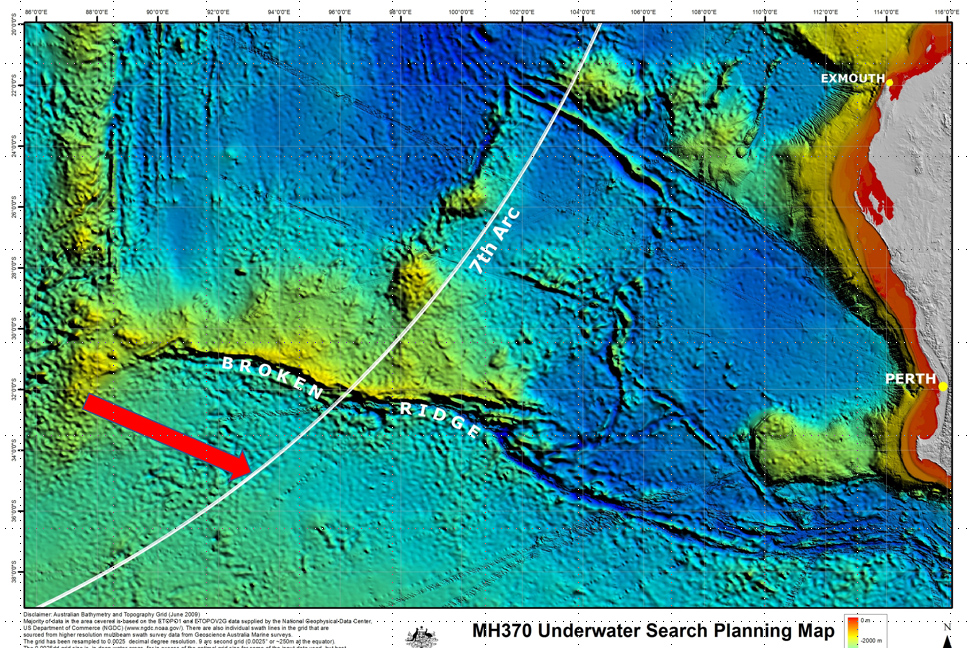
The study found three regions of interest but singled out one involving a route that set the South pole as the final waypoint and passed close to another waypoint called BEDAX off the tip of Sumatra.
“All possible MH370 endpoints of flight routes in any navigation mode and any speed mode have already been searched, within at least ± 25 NM of the 7th Arc (partially ± 40 NM),’’ the paper said.
“ This means that MH370 has either been missed in a previous search or recovered from a steep descent of around 15,000 fpm and glided out to an endpoint outside the previously searched area.
“There is only one Region of Interest, where we recommended a further analysis and search at around 34.4 °S near the 7th Arc, following a flight route from close to waypoint BEDAX using the LNAV lateral navigation mode with an ultimate waypoint of the South Pole on a track of 180°T due south, in long-range cruise speed mode and at a flight level between FL390 and FL403.’’
There have been a number of potential crash sites put forward over the past five years but there has been no sign of the plane despite two extensive searches.
International researchers using a new mathematical approach to analyzing the movement of debris in the ocean earlier this year proposed a search area extending north of areas already searched.
The analysis used "Markov chain models" to arrive at a crash location between latitudes 17°S and 33°S.
READ: New study suggests plane could be further north.
CSIRO modelling raised hopes that the wreckage would be found during the second search by Ocean Infinity by identifying several hot spots.
The failure to find the wreckage in a 120,000 sq. km area swept by Ocean Infinity’s high-tech fleet of sophisticated underwater autonomous vehicles left experts grappling with where to look next.
There have been several suggestions as experts rake over the data but little likely to be enough to convince the Malaysians to back another search.
University of Western Australia oceanographer Professor Charitha Pattiaratchi believes MH370 is lying just outside the area already searched.
Prof Pattiaratchi said UWA drift modeling indicated that the priority region to target would be between 33°S and 28°S along the 7th arc.
Pilots and a Canadian air safety investigator who argue the aircraft was deliberately ditched at the end of its flight believe it is further afield. Critical of findings the aircraft was uncontrolled when it hit the sea, they believe it would have glided well beyond the defined search areas.
The search area was widened in the later search by Ocean Infinity, but again nothing was found.
The Malaysian government has indicated it is open to restarting the search if credible new information becomes available and high-tech search company Ocean Infinity has said it is willing to undertake a further mission on a “no find, no fee" basis.
In the latest review, the scientists say they have scanned the Southern Indian Ocean for possible MH370 flight paths using a degree of precision they believe had not been applied previously.
They are planning another paper on their finding which, they say, merits deeper investigation.
READ: New claim lonely MH370 captain paced empty rooms.
Each had independently developed an MH370 flight model using the Boeing 777-200ER aircraft performance data, Rolls Royce Trent 892 fuel range and endurance data, Inmarsat satellite data and the Global Data Assimilation System (GDAS) weather data.
"The goal was to find all possible MH370 flight routes that fit the data within appropriate tolerances,'' a paper on the study said. "Additionally, the data would be checked using a set of correlations."
Using satellite data, the study assumed that the flight was automated and with no pilot inputs after it completed its turn south.
It looked at seven parameters: start time, latitude and longitude, flight level, lateral navigation method, initial bearing and speed control mode.
It considered flight paths with start latitudes ranging from 16.0°N to 4.3°S and start times from 18:41:00 UTC to 19:32:00 but before the aircraft reached the second arc at 19:41:03.
Initial true bearings from 150 degrees to 195 degrees were analyzed in steps of 1 degree covering all navigation and speed modes and altitudes from 29,000ft to 43,000ft.
The study found three regions of interest but singled out one involving a route that set the South pole as the final waypoint and passed close to another waypoint called BEDAX off the tip of Sumatra.
“All possible MH370 endpoints of flight routes in any navigation mode and any speed mode have already been searched, within at least ± 25 NM of the 7th Arc (partially ± 40 NM),’’ the paper said.
“ This means that MH370 has either been missed in a previous search or recovered from a steep descent of around 15,000 fpm and glided out to an endpoint outside the previously searched area.
“There is only one Region of Interest, where we recommended a further analysis and search at around 34.4 °S near the 7th Arc, following a flight route from close to waypoint BEDAX using the LNAV lateral navigation mode with an ultimate waypoint of the South Pole on a track of 180°T due south, in long-range cruise speed mode and at a flight level between FL390 and FL403.’’
There have been a number of potential crash sites put forward over the past five years but there has been no sign of the plane despite two extensive searches.
International researchers using a new mathematical approach to analyzing the movement of debris in the ocean earlier this year proposed a search area extending north of areas already searched.
The analysis used "Markov chain models" to arrive at a crash location between latitudes 17°S and 33°S.
READ: New study suggests plane could be further north.
CSIRO modelling raised hopes that the wreckage would be found during the second search by Ocean Infinity by identifying several hot spots.
The failure to find the wreckage in a 120,000 sq. km area swept by Ocean Infinity’s high-tech fleet of sophisticated underwater autonomous vehicles left experts grappling with where to look next.
There have been several suggestions as experts rake over the data but little likely to be enough to convince the Malaysians to back another search.
University of Western Australia oceanographer Professor Charitha Pattiaratchi believes MH370 is lying just outside the area already searched.
Prof Pattiaratchi said UWA drift modeling indicated that the priority region to target would be between 33°S and 28°S along the 7th arc.
Pilots and a Canadian air safety investigator who argue the aircraft was deliberately ditched at the end of its flight believe it is further afield. Critical of findings the aircraft was uncontrolled when it hit the sea, they believe it would have glided well beyond the defined search areas.
Have questions or want to share your thoughts?