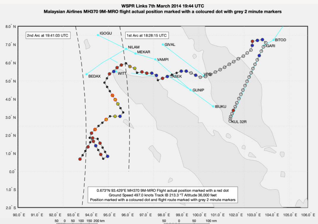
In a sensational development in the search for MH370, aerospace engineer Richard Godfrey has discovered that after following the coastline of Sumatra the Boeing 777 was put into a holding pattern for 22 minutes before proceeding south.
Mr. Godfrey is using a revolutionary new tracking technology called WSPRnet to track MH370 which it is hoped will lead to a new search.
READ: WSPRnet explained
READ: Mr. Godfrey's full comments here at the bottom of the blog
Using a set of tools (see below) Mr. Godfrey says he is “able to detect and track aircraft anywhere in the globe and at any time currently or historically going back as far as 2009.”
This system has been undergoing a number of tests that have been set up by an ex-Qantas Captain Mike Glynn and adjudicated by AirlineRatings.com which have been very successful.
READ: Qatar Airways launches huge fare sale for Australia
READ: Aussie whizz Hapgood to lead digital production of Boeing’s next aircraft.
READ: Ryanair’s O’Leary calls Boeing delusionary over MAX deal
Having verified the technology Mr. Godfrey is currently tracking MH370 and reports as follows with the map below;
"What I found out, without looking for it, was that MH370 entered a race track holding pattern at around 19:12 UTC:
"I was surprised to discover that not only did MH370 enter a holding pattern but that the holding pattern lasted for around 22 minutes until 19:34 UTC.
 Mr. Godfrey says that "this flight route of MH370 is a result of the WSPRnet analysis. The flight path is at a constant ground speed of 497 knots and a constant altitude of 36,000 feet. There is no contrived descent or ascent to match the Inmarsat satellite data. There are no contrived turns to match the Inmarsat satellite data timing or a fabricated sighting by Kate Tee.
"The Inmarsat satellite BTO and BFO data matches perfectly the timing, position, and track at the 1st Arc (18:28 UTC BTO and BFO), during the SATCOM call (18:40 UTC, BFO only) and the 2nd Arc (19:41 UTC BTO and BFO). On entering the holding pattern MH370 was 150 nm from the coast of Sumatra and 40 nm from the 2nd Arc."
The burning question is why did Captain Zaharie Shah or the person in control of MH370 allegedly put the 777 into a holding pattern?
Mr. Godfrey continues;
"If the pilot’s goal was to make MH370 disappear without a trace, then why waste fuel with a holding pattern and why not head directly to the most remote area possible of the Indian Ocean without deviation, asks Mr. Godfrey.
"The analysis by Victor Iannello and Yves Guillaume of the Microsoft Flight simulator data found on Zaharie Shah’s extensive home flight computer set up is a smoking gun. Zaharie Shah simulated a single flight from Kuala Lumpur via the Malacca Strait to the point of fuel exhaustion in the southern Indian Ocean.
"Professor Charitha Pattiaratchi says: “The only possible conclusion from an oceanographic and recovered debris perspective is that MH370 lies in the southern Indian Ocean.” A total of 33 pieces have been found by 16 unrelated people in six countries with most being identified as being from MH370 or a Boeing 777.
"Extensive underwater searches in the Indian Ocean along the 7th Arc (as defined by the last Inmarsat satellite data connection) by ATSB and Ocean Infinity have so far not located the wreckage of MH370."
Mr. Godfrey expects to complete the tracking of MH370 to its final resting place by the end of November with the results being the catalyst for another search.
Mr. Godfrey explains the set of tools thus:
“The WSPRnet Propagation Technical Analysis is based on the 2007 International Reference Ionosphere (IRI). The IRI is a permanent joint scientific project of the Committee on Space Research (COSPAR) and the International Union of Radio Science (URSI) started in 1968. It is the international standard empirical model for the terrestrial ionosphere since 1999.
“I use Proplab Pro V3.1 for tracing radio waves around the globe. Proplab Pro was one of the first ionospheric physics-based HF radio signal ray-tracing engines in the world for the PC and has been maintained and developed for over 30 years. It continues to be used by research organisations, scientists, engineers, students, the military and amateur radio operators around the world. It is one of the only software packages to reliably predict ionospherically refracted HF radio signal behaviour. It uses both three-dimensional models of the ionosphere as well as three-dimensional topographical data of the Earth to provide unprecedented detail in modelling HF radio signal propagation worldwide.
GDTAAA is a software application that I have developed that uses a Vincenty WGS84 navigation engine to track aircraft, a spherical navigation engine to track WSPRnet data links and anomalies. In addition, I use the Proplab Pro V3.1 engine with its embedded IRI 2007 ionospheric model to perform global ionospheric mapping and ray tracing.”
Mr. Godfrey says that "this flight route of MH370 is a result of the WSPRnet analysis. The flight path is at a constant ground speed of 497 knots and a constant altitude of 36,000 feet. There is no contrived descent or ascent to match the Inmarsat satellite data. There are no contrived turns to match the Inmarsat satellite data timing or a fabricated sighting by Kate Tee.
"The Inmarsat satellite BTO and BFO data matches perfectly the timing, position, and track at the 1st Arc (18:28 UTC BTO and BFO), during the SATCOM call (18:40 UTC, BFO only) and the 2nd Arc (19:41 UTC BTO and BFO). On entering the holding pattern MH370 was 150 nm from the coast of Sumatra and 40 nm from the 2nd Arc."
The burning question is why did Captain Zaharie Shah or the person in control of MH370 allegedly put the 777 into a holding pattern?
Mr. Godfrey continues;
"If the pilot’s goal was to make MH370 disappear without a trace, then why waste fuel with a holding pattern and why not head directly to the most remote area possible of the Indian Ocean without deviation, asks Mr. Godfrey.
"The analysis by Victor Iannello and Yves Guillaume of the Microsoft Flight simulator data found on Zaharie Shah’s extensive home flight computer set up is a smoking gun. Zaharie Shah simulated a single flight from Kuala Lumpur via the Malacca Strait to the point of fuel exhaustion in the southern Indian Ocean.
"Professor Charitha Pattiaratchi says: “The only possible conclusion from an oceanographic and recovered debris perspective is that MH370 lies in the southern Indian Ocean.” A total of 33 pieces have been found by 16 unrelated people in six countries with most being identified as being from MH370 or a Boeing 777.
"Extensive underwater searches in the Indian Ocean along the 7th Arc (as defined by the last Inmarsat satellite data connection) by ATSB and Ocean Infinity have so far not located the wreckage of MH370."
Mr. Godfrey expects to complete the tracking of MH370 to its final resting place by the end of November with the results being the catalyst for another search.
Mr. Godfrey explains the set of tools thus:
“The WSPRnet Propagation Technical Analysis is based on the 2007 International Reference Ionosphere (IRI). The IRI is a permanent joint scientific project of the Committee on Space Research (COSPAR) and the International Union of Radio Science (URSI) started in 1968. It is the international standard empirical model for the terrestrial ionosphere since 1999.
“I use Proplab Pro V3.1 for tracing radio waves around the globe. Proplab Pro was one of the first ionospheric physics-based HF radio signal ray-tracing engines in the world for the PC and has been maintained and developed for over 30 years. It continues to be used by research organisations, scientists, engineers, students, the military and amateur radio operators around the world. It is one of the only software packages to reliably predict ionospherically refracted HF radio signal behaviour. It uses both three-dimensional models of the ionosphere as well as three-dimensional topographical data of the Earth to provide unprecedented detail in modelling HF radio signal propagation worldwide.
GDTAAA is a software application that I have developed that uses a Vincenty WGS84 navigation engine to track aircraft, a spherical navigation engine to track WSPRnet data links and anomalies. In addition, I use the Proplab Pro V3.1 engine with its embedded IRI 2007 ionospheric model to perform global ionospheric mapping and ray tracing.”Have questions or want to share your thoughts?


