New satellite system to make aviation safer
17 April, 2018
3 min read

New satellite assisted aircraft approaches to be tested in Australia will be eight times safer than those using ground-based navigation aids, according to the head of air navigation provider Airservices Australia.
Airservices will lead an aviation trial of Satellite Based Augmentation System (SBAS) technology using a Geosciences Australia test bed to better determine the position of aircraft.
The trial is due to start in June and is part of a wider two-year program assessing the benefits of the technology.
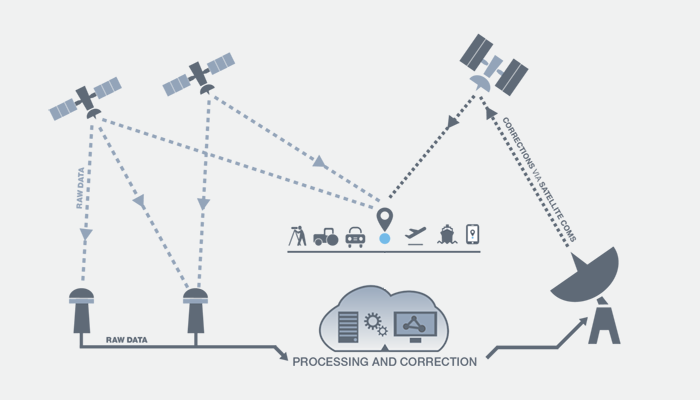
It will see GPS positioning signals already available in Australia from constellations of international satellites augmented by a ground-based correction service to improve their accuracy. They're then transmitted to a geostationary satellite and returned to Earth.
Airservices chief executive Jason Harfield said approaches using SBAS would be able to more accurately pinpoint aircraft and predicted regional carriers Rex and QantasLink, as well as the Royal Flying Doctor Service, would be big beneficiaries.
“It will improve safety, guiding pilots with greater accuracy, especially those flying into regional aerodromes operating under Instrument Flight Rules (IFR),’’ he said.
“SBAS assisted approaches are eight times safer than those which use ground-based navigation aids.
“This extraordinary new technology, which provides improved navigation and timing over GPS, will also decrease the likelihood of ‘go-arounds’ and cancellations or diversions due to variable weather.”
The aviation trial is one of 25 looking at the benefits of SBAS technology as part of a program that has seen the Australian government provide $A12 million in funding and its New Zealand counterpart kick in $A2 million.
The technology has already been used to help dock the world’s fifth-biggest ocean liner, the Ovation of the Seas, in Sydney Harbour and other tests involve areas such as automated driving, agriculture, rail and mining.
While many countries are already using the first generation of SBAS, Australia in 2017 became the first to test second-generation technology and an integrated system, called Precise Point Positioning, that provides a position within about 10cms.
This compares to the five- to 10m accuracy of a standalone GPS.
Airservices will test the first-generation single frequency technology as well as a dual frequency /multiple constellation system that further improves accuracy and the “Precise Point Positioning” system.
The trials involve global technology companies GMV, Inmarsat and Lockheed Martin. The Cooperative Research Centre for Spatial Information (CRCSI) is managing the trials as well as evaluation and reporting.

Get the latest news and updates straight to your inbox
No spam, no hassle, no fuss, just airline news direct to you.
By joining our newsletter, you agree to our Privacy Policy
Find us on social media
Comments
No comments yet, be the first to write one.