By joining our newsletter, you agree to our Privacy Policy
Share this story
Steve Creedy
10 January, 2018
Deep sea search company Ocean Infinity has confirmed it has inked a deal to continue the search for missing Malaysia Airlines flight MH370 and says the search will start "imminently" in the zone identified by the Australian Transport Safety Bureau.
The company said the project's sophisticated surface vessel, Seabed Constructor, was now close to the search area and the “no find, no fee” sweep, which was expected to last 90 days.
“We are pleased that our offer to continue the search for missing Malaysian Airlines flight MH370 has been accepted by the Government of Malaysia, who I would like to thank for giving us the opportunity,’’ OI chief executive Oliver Plunkett said.
“Whilst there can be no guarantees of locating the aircraft, we believe our system of multiple autonomous vehicles working simultaneously is well suited to the task at hand.
“I wish our team the best of luck in their endeavours and sincerely hope that we will be able to play a part in providing some answers to the many people affected by this tragedy.”
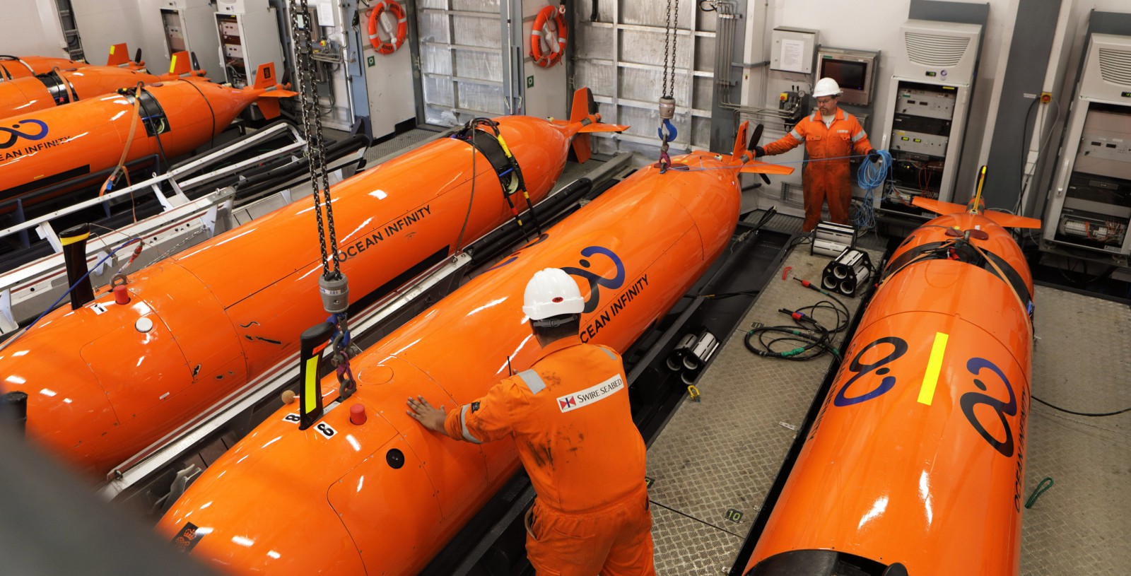
The company also confirmed it would use up to eight Hugins autonomous underwater vehicles capable of operating to depths of 6000m and already tested to just above that limit.
The company did not give any details of the agreement but Channel News Asia reported earlier today that it was a tiered arrangement that would see the company paid up to $US50 million if it is found in the ATSB search area and $US70 million if it is found beyond that.
The report said the it would be paid $US20 million if the plane, which went missing in 2014 with 239 passengers and crew on board, was found in first 5000 sq. km.
The search will begin in a 25,000 sq. km area designated by experts in 2016 as the most likely crash site.
Drift modelling and analysis of satellite imagery significantly boosted confidence among Australian experts that the wreckage of the Boeing 777, which went missing in March 2014, is in the southern half of a 25,000 sq. km.
Scientists identified a location at latitude 35.6°S and longitude 92.8°E, near the seventh arc defined by satellite data, as the most likely location for the missing plane.
However, if the wreckage is not found in the 25,000 sq. km search area the vessel will head north to areas proposed by other experts.
Ocean Infinity said the use of “free flying AUVs” meant they were not tethered and could collect higher quality data.
The AUVs are equipped with side scan sonar, multi-beam echo sounder, sub-bottom profiler, HD camera, conductivity/temperature/depth sensor, self-compensating magnetometer, synthetic aperture sonar and a turbidity sensor.
They can scour up to 1200 sq. kms a day, meaning the initial search area could be covered in about three weeks.
The discovery of the wreckage will leave the Malaysian Government facing the question of how to retrieve the debris and particularly the crucial flight data and cockpit voice recorders.
The quickest way to start the process would be to use the Seabed Constructor.
The Seabed Constructor. Photo: Swire Seabed.
Sources have told AirlineRatings the sophisticated vessel is carrying remotely operated vehicles and a 6000-metre rated recovery winch capable of retrieving debris at the kind of depths at which it is likely to be located.
They also saw the Seabed Constructor as the “asset of opportunity” if the wreckage is located before the winter weather sets in.
Crucially, the ship is equipped with a dynamic positioning system that allows it to stay on station above the tethered robots as they work.
Also on board to assist with analysis of sonar data are staff from Deep Ocean Search, a company which focuses on “ultra-deep water services” in depths of up to 6000m.
DOS was instrumental in finding the SS City of Cairo, sunk by a German U-boat in 1942 while carrying 100 tonnes of silver coins from Bombay to England.
Under contract to the UK government, DOS and recovered tons of silver coins from a depth of 5150m, a world record at the time and more than 1300m deeper than the Titanic.
DOS told AirlineRatings it was unable to answer questions because it had signed a non-disclosure agreement with Ocean Infinity.
But its website indicated operating at extreme depth was not without “serious technical difficulties’ which resulted in multiple breakdowns but were eventually resolved.
ROV’s differ from the torpedo-shaped autonomous underwater vehicles being deployed in the search in that they are tethered to the ship by a cable and operated in real-time from consoles.
They have cameras and often come equipped with sonar as well as thrusters and often manipulating arms
Sensitive electronics and data storage on deep water ROVs are protected in titanium vessels and an expert said every connector, cable and device had to withstand the pressure.
He said there were many ROVs designed to run at a depth of about 3000m but very few work class ROVs rated for 6000m.
However, he said the technology for deep dives was mature.
“The ones around that can be used for this sort of thing are typically designed for something other than the oil and gas industry,’’ he said.
Much deeper dives were conducted by the bathyscaphe Trieste in 1960 and by movie director James Cameron in 2012. Both dived on the Challenger Deep in the Pacific Ocean’s Mariana Trench and reached depths of almost 11,000m .
A Japanese remotely operated underwater vehicle called Kaiko established a depth record for umanned probes in 1995 when it reached the bottom of the Challenger Deep. Others to explore the abyss were Japan’s ABISMO, the US hyrbrid ROV Nereus and China’s Haidou-1.
Deep sea search company Ocean Infinity has confirmed it has inked a deal to continue the search for missing Malaysia Airlines flight MH370 and says the search will start "imminently" in the zone identified by the Australian Transport Safety Bureau.
The company said the project's sophisticated surface vessel, Seabed Constructor, was now close to the search area and the “no find, no fee” sweep, which was expected to last 90 days.
“We are pleased that our offer to continue the search for missing Malaysian Airlines flight MH370 has been accepted by the Government of Malaysia, who I would like to thank for giving us the opportunity,’’ OI chief executive Oliver Plunkett said.
“Whilst there can be no guarantees of locating the aircraft, we believe our system of multiple autonomous vehicles working simultaneously is well suited to the task at hand.
“I wish our team the best of luck in their endeavours and sincerely hope that we will be able to play a part in providing some answers to the many people affected by this tragedy.”
The company also confirmed it would use up to eight Hugins autonomous underwater vehicles capable of operating to depths of 6000m and already tested to just above that limit.
The company did not give any details of the agreement but Channel News Asia reported earlier today that it was a tiered arrangement that would see the company paid up to $US50 million if it is found in the ATSB search area and $US70 million if it is found beyond that.
The report said the it would be paid $US20 million if the plane, which went missing in 2014 with 239 passengers and crew on board, was found in first 5000 sq. km.
The search will begin in a 25,000 sq. km area designated by experts in 2016 as the most likely crash site.
Drift modelling and analysis of satellite imagery significantly boosted confidence among Australian experts that the wreckage of the Boeing 777, which went missing in March 2014, is in the southern half of a 25,000 sq. km.
Scientists identified a location at latitude 35.6°S and longitude 92.8°E, near the seventh arc defined by satellite data, as the most likely location for the missing plane.
However, if the wreckage is not found in the 25,000 sq. km search area the vessel will head north to areas proposed by other experts.
Ocean Infinity said the use of “free flying AUVs” meant they were not tethered and could collect higher quality data.
The AUVs are equipped with side scan sonar, multi-beam echo sounder, sub-bottom profiler, HD camera, conductivity/temperature/depth sensor, self-compensating magnetometer, synthetic aperture sonar and a turbidity sensor.
They can scour up to 1200 sq. kms a day, meaning the initial search area could be covered in about three weeks.
The discovery of the wreckage will leave the Malaysian Government facing the question of how to retrieve the debris and particularly the crucial flight data and cockpit voice recorders.
The quickest way to start the process would be to use the Seabed Constructor.
The Seabed Constructor. Photo: Swire Seabed.
Sources have told AirlineRatings the sophisticated vessel is carrying remotely operated vehicles and a 6000-metre rated recovery winch capable of retrieving debris at the kind of depths at which it is likely to be located.
They also saw the Seabed Constructor as the “asset of opportunity” if the wreckage is located before the winter weather sets in.
Crucially, the ship is equipped with a dynamic positioning system that allows it to stay on station above the tethered robots as they work.
Also on board to assist with analysis of sonar data are staff from Deep Ocean Search, a company which focuses on “ultra-deep water services” in depths of up to 6000m.
DOS was instrumental in finding the SS City of Cairo, sunk by a German U-boat in 1942 while carrying 100 tonnes of silver coins from Bombay to England.
Under contract to the UK government, DOS and recovered tons of silver coins from a depth of 5150m, a world record at the time and more than 1300m deeper than the Titanic.
DOS told AirlineRatings it was unable to answer questions because it had signed a non-disclosure agreement with Ocean Infinity.
But its website indicated operating at extreme depth was not without “serious technical difficulties’ which resulted in multiple breakdowns but were eventually resolved.
ROV’s differ from the torpedo-shaped autonomous underwater vehicles being deployed in the search in that they are tethered to the ship by a cable and operated in real-time from consoles.
They have cameras and often come equipped with sonar as well as thrusters and often manipulating arms
Sensitive electronics and data storage on deep water ROVs are protected in titanium vessels and an expert said every connector, cable and device had to withstand the pressure.
He said there were many ROVs designed to run at a depth of about 3000m but very few work class ROVs rated for 6000m.
However, he said the technology for deep dives was mature.
“The ones around that can be used for this sort of thing are typically designed for something other than the oil and gas industry,’’ he said.
Much deeper dives were conducted by the bathyscaphe Trieste in 1960 and by movie director James Cameron in 2012. Both dived on the Challenger Deep in the Pacific Ocean’s Mariana Trench and reached depths of almost 11,000m .
A Japanese remotely operated underwater vehicle called Kaiko established a depth record for umanned probes in 1995 when it reached the bottom of the Challenger Deep. Others to explore the abyss were Japan’s ABISMO, the US hyrbrid ROV Nereus and China’s Haidou-1.