UPDATED: New MH370 study suggests it's further north
UPDATED: New MH370 study suggests it's further north
By Geoffrey Thomas Fri Jul 20, 2018
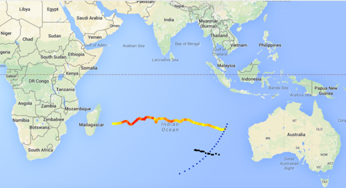
A new study by MH370 Independent Group (IG) member Richard Godfrey has completed a new drift analysis that asks could have MH370 crashed further north than was previously searched.
The location would be off Exmouth, Western Australia and the drift analysis supports the article in Airlineratings.com on June 10.
But one of the world’s leading oceanographers, the University of Western Australia’s Professor Charitha Pattiaratchi, said it was highly unlikely the debris was that far north.
On the website, Radiant Physics IG lead Victor Iannello says that Mr. Godfey has concluded: “that the recovered aircraft debris from the beaches of East Africa could have originated from potential impact sites as far north as 20.5°S latitude.”
“He is recommending that a new subsea search cover the part of the 7th arc between 25°S and 20°S latitudes based on his new drift analysis,” says Mr. Iannello.
“As further justification for a new search to the north, he also cites the reconstructed flight path over Cocos Island ending at 22°S that we [IG] discussed in the previous post.”
Mr. Iannello says “the new drift analysis highlights the timing and location of the discovery of four parts that were found with barnacles still attached.”
Drift analysis was done by Mr Godfrey
“These pieces are particularly important because the presence of marine life on a part suggests that the timing of the discovery was close in time to the arrival of the part. Any marine life that is attached to a beached part either falls off or is picked off due to decomposition and scavenging, so the presence of barnacles is a good indicator that the part was recently beached.”
Mr. Iannello says that the four parts found with barnacles that were considered in the drift analysis were:
The flaperon found on Reunion Island after drifting about 508 days
The fragment of the engine cowling (“Roy”) found in Mossel Bay, South Africa, after drifting about 655 days
The fragment of the cabin divider found on Rodrigues after drifting about 753 days
The outboard flap found in Pemba, Tanzania, after drifting about 835 days
The drift analysis put together by Mr. Godfrey uses the database of buoy positions that are tracked as part of the Global Drift Program (GDP).
“The data sets from 96 buoys were used to build a model of the Indian Ocean with a spatial resolution of 1° of latitude and longitude, and 1 day of temporal resolution. Both drogued and undrogued buoys were considered,“ says Mr Iannello.
Prof. Pattiaratchi believes the debris is just outside an area already searched and would like a new wider search to focus on the latitudes from 28S to 36S to encompass both UWA’s and the CSIRO’s modeling.
He said the models used by CSIRO and UWA used all the available global sets of data and were more detailed, running at hourly intervals over a grid of 10kms. They also used data that exactly corresponded with the time of simulation.
“All of the smaller scale oceanographic features are well resolved in these models’’ he said. ‘”The IG drift information is from surface drifter tracks overaged daily over a grid of 100km. These are very much lower spatial and temporal resolution than the oceanographic drift models and thus underestimate the actual velocities “
Prof. Pattiaratchi said the IG tracks used data from a set of drifting buoys spread over many years since 1992.
This resulted in spatial and temporal averaging biased towards a more northerly location due to lower mean currents.
“Also, models that CSIRO and UWA use indicated very distinct change in the velocities and the time to get to the western Indian Ocean when particles were released north of 28 °S,’’ he said. “There is a very clear difference in the drift patterns predicted by release points south of 28 °S compared to that further north.”