More serious questions raised about the ATSB's review of MH370 data

By Geoffrey Thomas Sun Apr 24, 2022
More questions are being raised about the ATSB's review of MH370 search data with, incredibly, the two maps in its report apparently showing different, and both incorrect, locations of Mr Richard Godfrey's proposed site of MH370 with the maps out of sync with the original search map issued in 2017.
On Friday, April 22, 2022, the Australia Transport Safety Bureau issued the report of the review of its search data by Geoscience Australia in response to Mr Godfrey’s proposed location of MH370 based on his revolutionary MH370 tracking using WSPRnet technology.
The ATSB stated that; “The Geoscience Australia report notes that it is highly unlikely that there is an aircraft debris field within the area reviewed.”
But the review only looked at 29 per cent of the requested area and the report also stated multiple times that “further data acquisition” and “additional data acquisition” are required.
Even more serious are the disturbing inconsistencies when you compare the ATSB’s report titled “The Operational Search for MH370” dated October 3, 2017, to the Geoscience report titled “MH370 Data Review – Final Report” dated March 8, 2022, with the maps of the underwater search area apparently totally out of alignment.
SEE the podcast: Flight Safety Detectives dissect the Netflix doco “Downfall”.
READ: Can the giant AN-225 fly again?
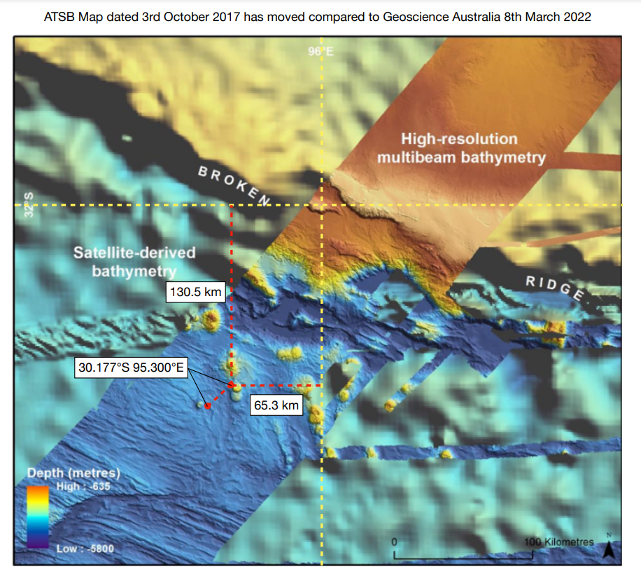
The proposed crash location 33.177°S 95.300°E has apparently moved 23.8 km further southwest on the current Geoscience maps as shown below.
A closer examination of the ATSB report also reveals the following
 The two maps from the new review report with the “supposed correct location” shown by the yellow dotted lines are below. But this location is different using the latitude and longitude used in the ATSB graphic from its 2017 report which everyone has been using as a reference.
In Geoscience’s first map in the report issued Friday, April 22 this new – and likely incorrect – location for the latitude and longitude is indicated by the yellow dotted lines yet Geoscience positions the location six nautical miles to the southwest.
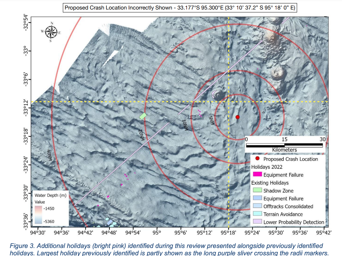
The two maps from the new review report with the “supposed correct location” shown by the yellow dotted lines are below. But this location is different using the latitude and longitude used in the ATSB graphic from its 2017 report which everyone has been using as a reference.
In Geoscience’s first map in the report issued Friday, April 22 this new – and likely incorrect – location for the latitude and longitude is indicated by the yellow dotted lines yet Geoscience positions the location six nautical miles to the southwest.
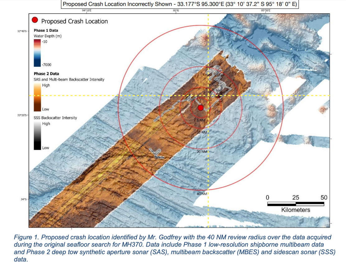 In the second map in the same report, the location is now four nautical miles to the southeast of the “proposed site” which again is marked by the yellow dotted lines but as stated this also differs from the original report.
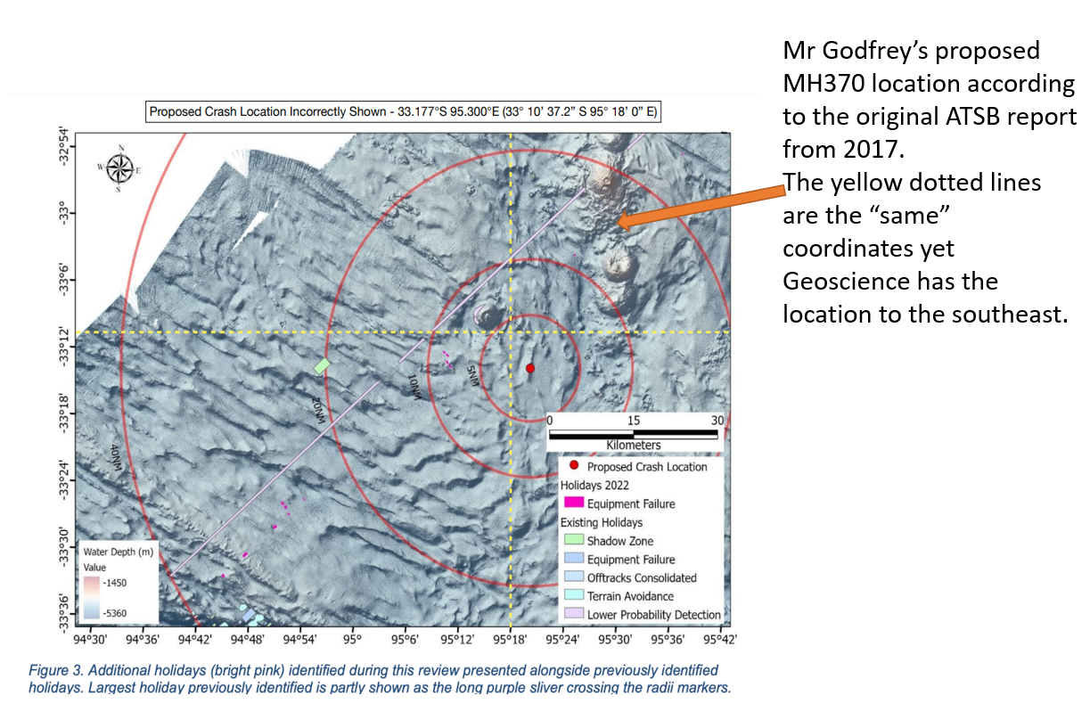
 Here is the same map showing where Mr Godfrey’s location is according to the original ATSB 2017 map.
 Mr Godfrey told AirlineRatings.com that “if it is true that the proposed crash location has been incorrectly mapped twice in the new report, then my confidence in the report’s findings dwindles”.
Famous wreck hunter Blaine Gibson who has found more MH370 debris than any other person said "what really bothers me is why a "Final Report" dated March 8, 2022, is held until April 22 and quickly released in such sloppy incomplete form, and with only 29 per cent reviewed.
"I have gotten used to brilliant fast professional work of ATSB in identifying and analysing MH370 debris. This is a departure from that standard."
Mr Godfrey told AirlineRatings.com that “if it is true that the proposed crash location has been incorrectly mapped twice in the new report, then my confidence in the report’s findings dwindles”.
Famous wreck hunter Blaine Gibson who has found more MH370 debris than any other person said "what really bothers me is why a "Final Report" dated March 8, 2022, is held until April 22 and quickly released in such sloppy incomplete form, and with only 29 per cent reviewed.
"I have gotten used to brilliant fast professional work of ATSB in identifying and analysing MH370 debris. This is a departure from that standard."
- The bathymetry maps from ATSB and Geoscience Australia are different.
- The latitude and longitude positions of the bathymetry maps differ.
- The position of the crash location on the bathymetry maps included in the latest Geoscience report is wrong using the latitude and longitude shown on their maps.
- The position of the crash location on the bathymetry maps included in the latest Geoscience report is wrong both in the wide-area view and the narrow area close up view with differing errors.
The two maps from the new review report with the “supposed correct location” shown by the yellow dotted lines are below. But this location is different using the latitude and longitude used in the ATSB graphic from its 2017 report which everyone has been using as a reference.
In Geoscience’s first map in the report issued Friday, April 22 this new – and likely incorrect – location for the latitude and longitude is indicated by the yellow dotted lines yet Geoscience positions the location six nautical miles to the southwest.
In the second map in the same report, the location is now four nautical miles to the southeast of the “proposed site” which again is marked by the yellow dotted lines but as stated this also differs from the original report.
Here is the same map showing where Mr Godfrey’s location is according to the original ATSB 2017 map.
Mr Godfrey told AirlineRatings.com that “if it is true that the proposed crash location has been incorrectly mapped twice in the new report, then my confidence in the report’s findings dwindles”.
Famous wreck hunter Blaine Gibson who has found more MH370 debris than any other person said "what really bothers me is why a "Final Report" dated March 8, 2022, is held until April 22 and quickly released in such sloppy incomplete form, and with only 29 per cent reviewed.
"I have gotten used to brilliant fast professional work of ATSB in identifying and analysing MH370 debris. This is a departure from that standard."
Have questions or want to share your thoughts?