The search for missing Malaysia Airlines Flight 370 has been extended to the beginning of next year after winter weather conditions delayed the deployment of specialised underwater search vehicles.
The Australian Transport Safety Bureau says the underwater vehicles are now being loaded on ships to rejoin the search, which it estimates will now end in in January-February instead of December.
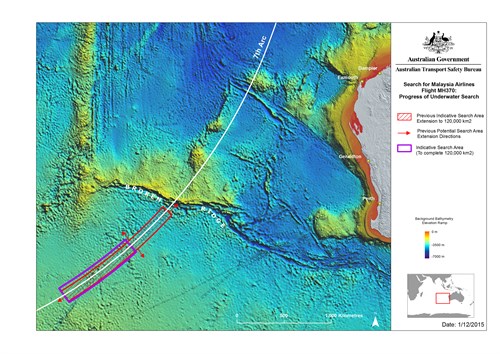
Two ships, the Fugro Equator and the Chinese vessel Dong Hai Jui 101, are still involved in sweeping the 120,000 sq km search area, more than 110,000sq kms of which has been searched so far.
The Dong Hai Jui 101 is berthed in Fremantle loading a remotely operated vehicle (ROV), the Remora III, which will be used by US company Phoenix International to look a number of sonar contacts identified during previous deep tow operations.
“None of the sonar contacts targeted for reacquisition exhibit the characteristics of a typical aircraft debris field and are therefore not classified as category 1 sonar contacts,’’ the ATSB said in its weekly update. “However some exhibit man-made properties and therefore must be investigated further to be positively eliminated.
“Winter weather conditions have, until now, prevented the safe deployment of the ROV, but now sea states are improving.”
High interest Category 1 sonar contacts are rare and only two have been found so far, one of which was subsequently found to be rock field and the other an old wooden shipwreck.
The Fugro Equator has been using a “towfish” equipped with side scan sonar and multi-beam echo sounders to continue the search.
It left the search area on October 15 for the Australian Marine Complex Henderson, 23kms south of Perth, to pick up a sonar-equipped autonomous underwater vehicle. The battery-powered, self-propelled AUV is used to scan areas which cannot be searched effectively using the towfish.
The Malaysia Airlines Boeing 777 disappeared with 239 passengers and crew on board in March, 2014, while flying between Kuala Lumpur and Beijing.
There have been a number of theories as to what happened during the light but the only hard evidence so far has come from satellite “handshakes’’ between the plane and a geostationary satellite.
The ATSB worked with satellite operator Inmarsat and other organisations globally to use the pings to determine a search area in which the aircraft was considered most likely to have crashed.
The governments of Malaysia, Australia and China have said the search will be suspended if the wreckage is not found in the `120,000 sq km search area and there is no further credible evidence identifying a specific location.


