A senior Boeing 777 captain, Simon Hardy, believes he has calculated exactly where the missing Malaysia Airlines flight MH370 may have crashed into the Southern Indian Ocean.
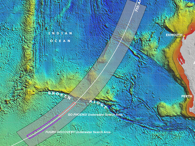
The position is S38.082 E87.400 (latitude and longitude using decimals rather than minutes).
According to David Learmount of FlightGlobal arguably the world’s most respected airline safety editor the location given by the experienced captain “is not fundamentally at odds with the present MH370 search assumptions, being in much the same part of the southeastern Indian Ocean.”
However Mr Learmount adds that it is “just outside the core target area currently being trawled by a search team led by the Australian Transport Safety Bureau (ATSB).”
Capt Simon Hardy’s calculations are based on a combination of data which include the Inmarsat satellite communication “handshake arcs”, his expertise in 777 performance calculation, and some mathematical “reverse engineering” of the navigation geometry known to apply to this flight.
“Hardy is aware that many very able people have theories about MH370, not least those advising the search, but believes the result of his calculations is worthy of examination, and hopes the ATSB will find the result useful,” said Mr Learmount.
“I respectfully recommend it to the MH370 search team,” Hardy told FlightGlobal.
Captain Hardy is an experienced airline pilot and currently works as a senior 777 captain for a major international airline. “Like other aviators he was distressed by the MH370 loss, and his concern that relatives of those on board might never know what happened inspired him to begin a geometric investigation of known MH370 navigational facts. He emerged with a set of conclusions that enabled him to isolate what he believes to be MH370’s actual track,” said Mr Learmount.
He explained his rationale and how the result emerged to FlightGlobal thus: “Rather than picking speeds and a route at random and making them fit with the [satcom handshake] arcs, I have managed to let the arcs tell us both the speed and direction, and finally a location – the exact track between arcs 4 and 6 – where it was doing that speed and heading. I have ‘reverse engineered’ it.”
He continues: “I was expecting to have to deduce a path from waypoint ANOKO [where Hardy calculates the 777 first turned southward] for the aircraft to get to this identified track across arcs 4-6, but then found to my amazement that the track line, when extended north from the 5th arc over a very large distance, went within 2nm of ANOKO. This was the final and strongest eureka moment!”
Mr Learmount adds: “The “reverse engineering” involved testing a series of plausible tracks southward over the Indian Ocean from the 777’s last known position, and discovering the only trajectory that – uniquely – matches the ratio of actual elapsed times between the consecutive Inmarsat/MH370 “handshakes”. He then found, subsequently, that certain known data, when tested against that navigational trajectory, made sense. For example, on that identified track, the actual elapsed time between “handshake arcs” would occur if the 777 was flying at its long-range cruise speed – possibly a coincidence, but a likely choice by the person directing the flight.
The ATSB told AirlineRatings.com that while they had not yet seen Captain Hardy’s report they “remained confident in their analysis and will continue the search in the high priority areas we have determined.”


